Programmes
BSc in Geographic Information and Earth Observation Science
Program Code
BSC GISLevel
undergraduateDuration
4 yearsOffered as
Generic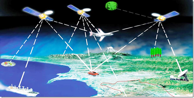
Program Description
Geographic Information Science (GIScience) is the science underlining the acquisition, visualisation and analysis of spatial data. It is an important tool for management of geo-spatial information. Since the advent of computerized geographic information systems in the 1960s, as well as the subsequent development of software and computing power, maps have become a much more widespread means for managing, analysing and communicating geospatial information. The extensive demand for geographic information science skills has entailed a significant role for geography. Indeed, although geographic information science is a multi-disciplinary endeavour, geographical theories have produced the bulk of what now comprise the core knowledge areas of the field. This undergraduate level programme is designed to provide all basic level information in GIS and remote sensing and their potential applications in Earth and climate science research.
Geo-information technologies offer tools for data management through database systems, acquisition, processing and integration to understand the dynamic nature of environmental challenges across a spatio-temporal domain. This is because environmental challenges are multi-disciplinary and complex in nature. Dealing with these challenges involves huge volumes of data and also requires a systems approach to integrate several processes and data layers to understand and model their behaviour for decision making.
As a country, Malawi faces numerous challenges such as population growth, climate variability, disasters, environmental degradation and the need to explore adequate resources to sustain the growing population. These issues have a spatio-temporal dimension and geo-information technologies would provide some tools to help address some of the issues. The programme will develop skills of highly trained professionals who will manipulate and analyse spatial data for timely decision making.
Structure of the program
Sem
1
1
-Chemistry I
-Algebra & Trigonometry
-Biology I
-Physics I
-Language and Communication
-Introduction to Computer Application
-Algebra & Trigonometry
-Biology I
-Physics I
-Language and Communication
-Introduction to Computer Application
Sem
2
2
-Technical and Business Communication
-Physics II
-Biology II
-Computer Programming
-Chemistry II
-Calculus I
-Physics II
-Biology II
-Computer Programming
-Chemistry II
-Calculus I
Sem
3
3
-Principles of Geographical Information Science
-Principles of Remote Sensing
-Calculus II
-Data Structures and Algorithms
-Databases
-Introduction to Space and Earth Science
-Principles of Remote Sensing
-Calculus II
-Data Structures and Algorithms
-Databases
-Introduction to Space and Earth Science
Sem
4
4
-Cartography
-Theories of Spatial Analysis
-Fundamentals of Geophysics
-Spatial Databases
-Object Oriented Programming
-Probability and Statistics
-Theories of Spatial Analysis
-Fundamentals of Geophysics
-Spatial Databases
-Object Oriented Programming
-Probability and Statistics
Sem
5
5
-Global Positioning Systems (GPS)
-Mathematical Methods I
-Geospatial Systems Analysis and Design
-Sensors and Platforms I
-Spatial Organisation
-Principles of Image Analysis
-Mathematical Methods I
-Geospatial Systems Analysis and Design
-Sensors and Platforms I
-Spatial Organisation
-Principles of Image Analysis
Sem
6
6
-Spatial Data Analysis
-Sensors and Platforms II
-Applied Geophysics
-Land Surveying
-Programming Principles in GIS
-Mathematical Methods II
-Sensors and Platforms II
-Applied Geophysics
-Land Surveying
-Programming Principles in GIS
-Mathematical Methods II
Sem
7
7
-Governance and Management of Spatial Information
-Mobile Applications Development
-GIS in Climatology and Meteorology
-Geological Remote Sensing
-Data Standards and Interoperability
-Research Project I
-Mobile Applications Development
-GIS in Climatology and Meteorology
-Geological Remote Sensing
-Data Standards and Interoperability
-Research Project I
Sem
8
8
-GIS and Remote Sensing in Natural Resource Management
-Advanced Image Analysis
-Web Mapping
-GIS and Remote Sensing in Multi-hazard Risk Assessment
-Business Management and Entrepreneurship
-Research Project II
-Advanced Image Analysis
-Web Mapping
-GIS and Remote Sensing in Multi-hazard Risk Assessment
-Business Management and Entrepreneurship
-Research Project II
Malawians
Government Sponsored
650,000 MWK
per year
Self Sponsored
1,250,000 MWK
per year
SADC Citizen
Total Fees
4,500 USD
per year
Non-SADC Citizen
Total Fees
5,000 USD
per year
Eligibility
Entry in Year 1: MSCE, “O” Level, IGCSE, GCE at least strong credits in Mathematics and English and any four of the following; Geography, Computer Studies, Physics, Chemistry (or Physical Science), Agriculture and Biology.
Entry in Year 2: A-level with at least C grade in the following subject Physics, Chemistry and Mathematics and Computer Programming.